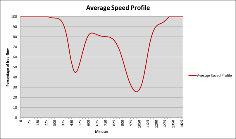
Traffic Aware

Valhalla respects historical traffic data as well as real-time traffic data out-of-the-box. Bring your own traffic data or ask us for e.g. TomTom Speed Profiles.
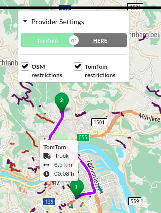
Multimodal Routing

Valhalla supports a wide variety of travel modes including public transit. Due to its pluggable nature, adding new profiles is fairly trivial.

Embeddable

Valhalla is written in C++ and thus can bind to most devices and frameworks seamlessly. The tiled graph hierarchy ensures a low memory footprint.

Valhalla Main Features

We're avid Valhalla contributors. Ask us anything or look at our past contributions. Check out our more in-depth article about FOSS routing engines as well.

Tiled Graph Hierarchy


  • Performance • Routing on a hierarchical graph is much more performant
  • Low memory • Only loads relevant tiles into memory
  • Regional extracts • Build the world once and easily create regional extracts

Functionality


  • APIs • Routing, Isochrones, Matrix, Map Matching, Elevation, TSP, Locate
  • Unique Flexibility • All costing options are fully dynamic, i.e. can be changed per request (vehicle dimensions, favor/avoid certain road features etc.)
  • Time Awareness • Specify departure/arrival times to make use of traffic data and public transit routing

Historical and Live Traffic


  • Optimal ETA • including historical and/or live traffic information optimizes the ETA for car-bound routing
  • Departure/Arrival • Valhalla support arbitrary departure and arrival times similar to Google Maps
  • APIs • Traffic integration works for all actions (route, isochrone, expansion etc) except Matrix

GIS • OPS PROJECTS AROUND VALHALLA

We created multiple projects around Valhalla to ease setting up and running this gorgeous routing engine, and visualizing its results.

DOCKER IMAGE

DEVOPS

Our Valhalla docker image is the easy entrypoint to running Valhalla locally. It's automating the whole software and graph build process with many customization options.                                                           

PYTHON LIBRARY

LIBRARIES

These Python bindings give direct access to the Valhalla C++ library, which a lot more performant than the regular HTTP Valhalla server. pip install pyvalhalla and enjoy!

HISTORICAL TRAFFIC

PROCESSING

We created a pipeline to convert TomTom's speed profiles (historical traffic data in 5 min bins) to Valhalla predicted traffic tiles. Enables future, traffic-aware trips via departure/arrival times.

TOMTOM VS OSM

WEB APP

This web app highlights the routing/isochrone differences of TomTom/HERE and OSM for both car and truck. This is the local setup via Docker of our live demo app: https://converter.gis-ops.com

GIS • OPS CONTRIBUTIONS

We maintain an excellent relationship to the Valhalla core team allowing us to efficiently communicate and implement our clients' needs and interests. Below are some of our contributions.

Shortest(-ish) path

Implementation of a shortest path considering only distance. However, due to missing hierarchy pruning, it's not guaranteed return the optimally shortest path for motorized vehicles.
Feature

Avoid Polygons

We implemented the ability to avoid entire polygon areas during path finding. Very useful to model temporary construction sites or similar.
Feature

Isodistances

We implemented isodistances on top of isochrones. That is: instead of maximum time you can specify maximum distance. Makes more sense with shortest instead of fastest path.
Feature

GIS • OPS UG

Mühlenstraße 8a
14167 Berlin

Telephone

TOP